The Importance of Paso de la Danta
How volunteers are rebuilding forest connections between Costa Rica's most biodiverse ecosystems as they race against development to finish the work.
In 1970, Jack Ewing arrived in Costa Rica's Southern Zone for what he thought would be a four-month job. He never left. By 1976, he had become a partner in Hacienda Barú, a cattle ranch carved from rainforest during the agricultural expansion that was transforming the country. What Ewing couldn't have known was that his personal journey from rancher to conservationist would mirror Costa Rica's own transformation, and that the forests slowly regrowing on his land would become a critical link in one of Central America's most ambitious conservation experiments.
Why the Corridor Was Needed
Ewing's early years at Hacienda Barú coincided with Costa Rica's deforestation crisis. Throughout the 1970s and 1980s, the country lost nearly 4% of its remaining forest cover annually to cattle ranching. By the mid-1980s, forest cover had crashed to as low as 21% of national territory. The cattle boom that brought prosperity to ranchers was leaving behind an archipelago of green islands surrounded by oceans of pasture.
But some of those green islands were spectacular. Conservationists Mario Boza and Álvaro Ugalde had spent the 1970s fighting to create national parks like Corcovado and Manuel Antonio, often living in them without salary, personally confronting illegal loggers and gold miners. Their fortress conservation strategy worked brilliantly. Within five years of enforcement beginning at Corcovado, peccary herds returned, scarlet macaws nested, jaguars reclaimed trails. Strong boundaries and relentless enforcement had saved some of Costa Rica's most extraordinary ecosystems.
But by the early 1990s, ecologists recognized a troubling reality. Isolated habitat patches, no matter how well protected, eventually lose biodiversity. Jaguars need pathways between Corcovado and the Talamanca mountains. Tapirs require genetic exchange between coastal and highland populations. Resplendent quetzals depend on altitudinal migration routes. Without connectivity, even the parks that Boza and Ugalde fought so hard to protect would slowly empty of their largest, most wide-ranging species. Fortress conservation had saved the core areas. Now Costa Rica needed to reconnect them.
Ewing witnessed this transition from Hacienda Barú's gradually regrowing forests. In 1993, Steve Stroud bought out Ewing's original partners. The following year, the two men petitioned the government to declare Hacienda Barú a National Wildlife Refuge, not as an isolated sanctuary but as a critical link in what would become the Paso de la Danta Biological Corridor. In 1998, they and other Southern Zone conservationists established ASANA (Asociación de Amigos de la Naturaleza del Pacífico Central y Sur) to provide institutional support. By 2000, ASANA had formalized the Paso de la Danta Biological Corridor, spanning 82,128 hectares across the cantones of Quepos, Pérez Zeledón, and Osa. What made this effort distinctive was its grassroots origins. While Costa Rica's first biological corridors in the early 1990s had been government-led, Paso de la Danta emerged from local communities, private landowners, and conservation organizations working together. If fortress conservation had saved core areas through exclusion and enforcement, this new model would depend on cooperation, voluntary participation, and communities willing to let forests regrow on marginal cattle land.
How the Corridor Works
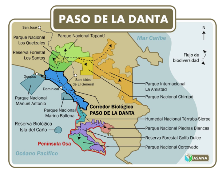
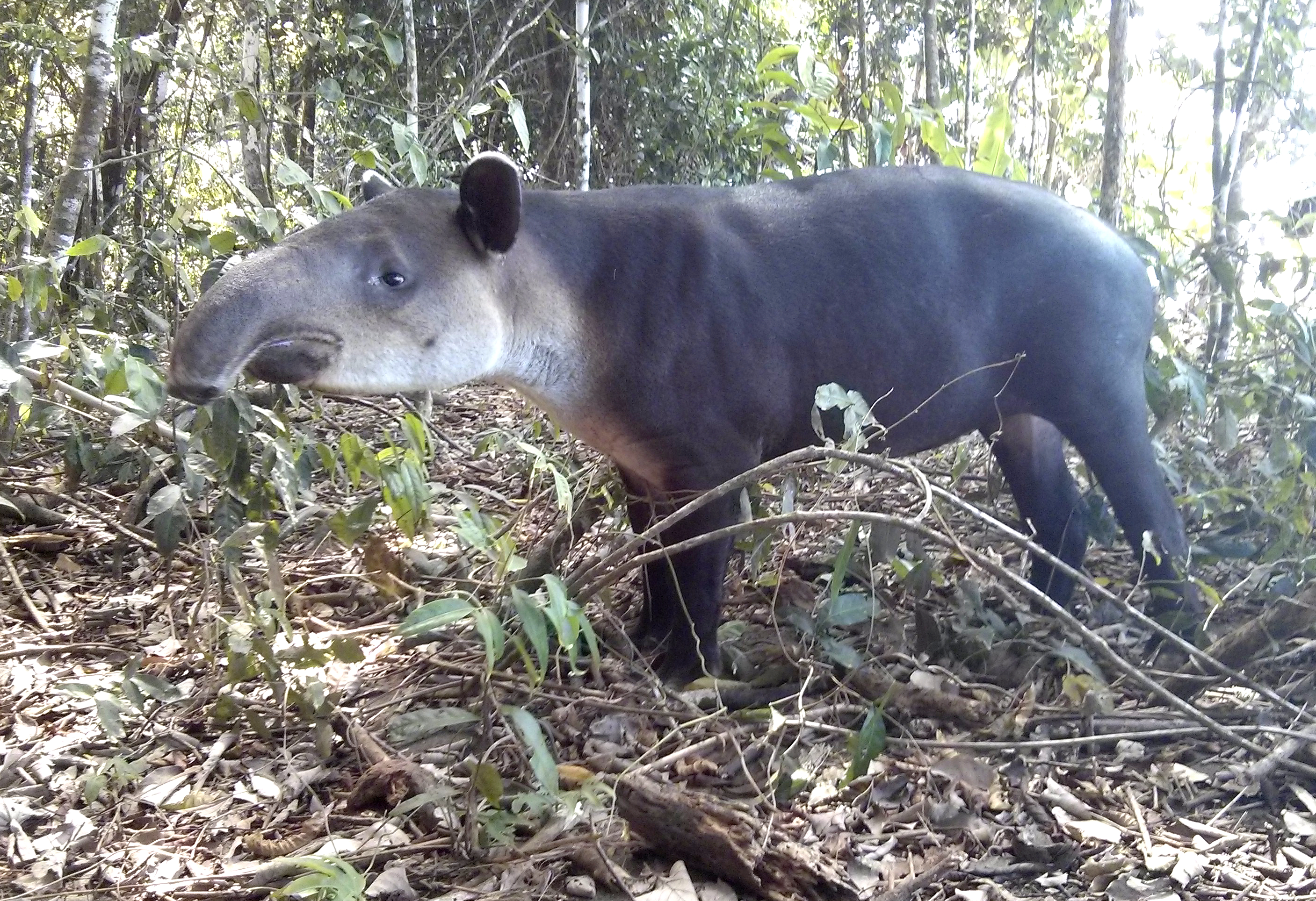
The name "Paso de la Danta" (Tapir's Passage) honors the Baird's tapir, Central America's largest land mammal. Tapirs serve as both umbrella and indicator species. Their habitat requirements overlap with dozens of other mammals, so protecting tapir range protects entire ecosystems. And because tapirs are sensitive to disturbance and require large, intact forests, their presence signals ecosystem health. If tapirs can thrive, so can jaguars, pumas, ocelots, scarlet macaws, and thousands of species dependent on mature forest.
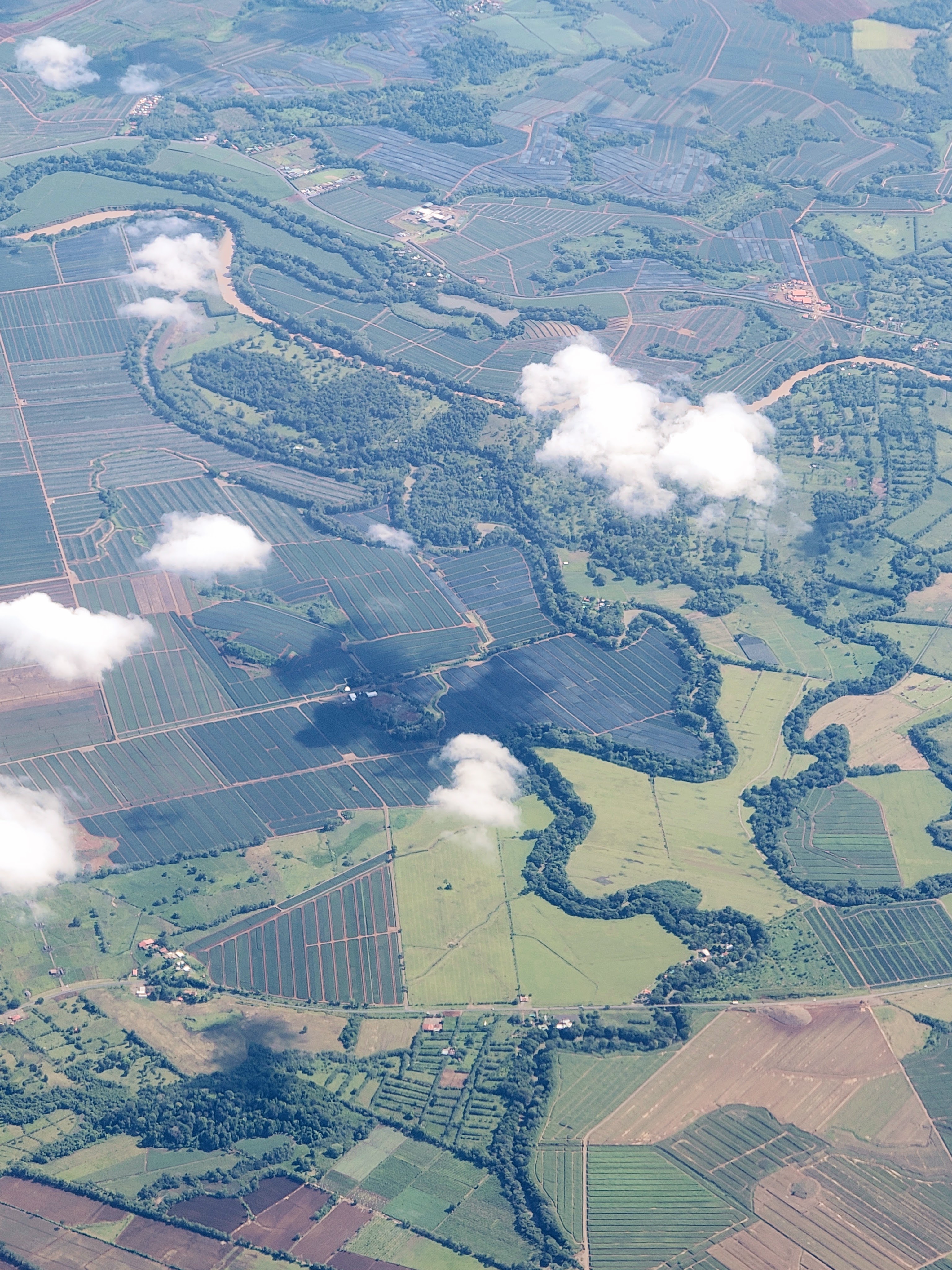
Paso de la Danta's 82,128 hectares aren't a continuous expanse of unbroken forest. The biological corridor designation creates a framework within which dozens of smaller wildlife corridors connect forest fragments across a working landscape. Forested valleys follow streams, wooded ridges connect hilltops, riparian forests line rivers, hedgerows run between pastures. A tapir might move from Corcovado's lowland forest through a series of these smaller corridors, spending days in one forest patch before crossing a cattle ranch under cover of darkness to reach the next wooded ridge. The biological corridor succeeds if working ranches between forest fragments maintain riparian zones, leave scattered trees for wildlife passage, and allow natural regeneration on steep slopes unsuitable for cattle. This creates a matrix of movement routes rather than a single contiguous path.
Ideal: Forested valleys provide unrestricted movement for wildlife through intact habitat
Sufficient? Even in agricultural areas, tree-lined rivers permit passage through biological deserts
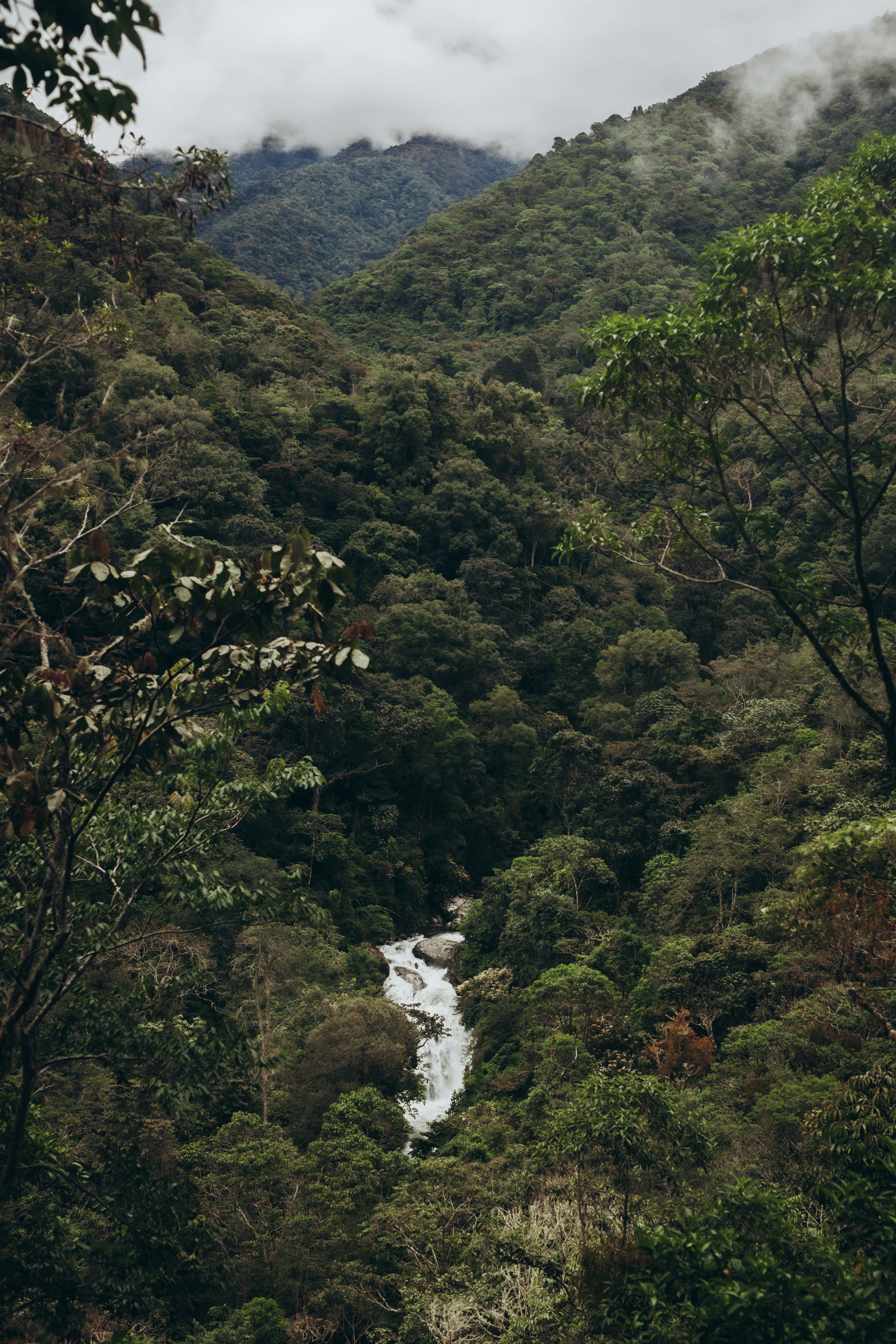
The corridor stretches from the lowland rainforests of the Osa Peninsula northeastward through Uvita, Dominical, and Quepos, continuing through the coastal mountains toward the Talamanca Cordillera, ultimately connecting lowland forest to the cloud forests of Los Quetzales National Park. This altitudinal gradient, from sea level at Golfo Dulce through approximately 1,100 meters in the Fila Costeña and extending toward the cloud forests above, creates a continuous pathway from coastal rainforest through premontane forest toward highland ecosystems. Jaguars from Corcovado could theoretically range through these mountains into higher elevations. Resplendent quetzals migrate seasonally between elevations. The endangered squirrel monkey, found nowhere else but the Osa Peninsula, depends on lowland connectivity for genetic viability.
This geographic sweep places Paso de la Danta at the heart of the Brunca Region, Costa Rica's most extreme biodiversity gradient. The region encompasses Corcovado National Park (National Geographic's "most biologically intense place on Earth"), La Amistad International Park (a UNESCO World Heritage Site), and Chirripó National Park. Across six cantones (Pérez Zeledón, Buenos Aires, Coto Brus, Osa, Corredores, and Golfito), ecosystems range from coastal mangroves and lowland rainforest to montane cloud forests. Paso de la Danta functions as one critical connection within this larger landscape, creating a pathway for wildlife to move between coastal lowlands and montane cloud forests along this extraordinary ecological gradient.
Making the corridor work requires convincing ranchers to accept Payment for Environmental Services, leave riparian zones intact, let steep slopes reforest naturally, and maintain scattered trees for wildlife passage. The economics explain why this needs volunteer persuasion rather than market forces.
Volunteers meet with landowners, help them navigate PES applications, organize tree planting projects, set camera traps to document which species are using the corridor, and when illegal clearing happens, file enforcement complaints with GPS coordinates.
Despite these economic headwinds, the corridor has recovered more than 30% of the forest cover lost during the deforestation crisis of the 1970s and 1980s. Over 35 years of volunteer effort, PES payments, and natural regeneration on abandoned pastures has created secondary forest where there was none. That forest is now slowly developing the ecological complexity needed to support wide-ranging species. But whether recovery can continue depends on preventing fragmentation and understanding what the science tells us about how corridors actually work.
Why Corridors Matter: The Science
The scientific case for Paso de la Danta comes from forty years of watching paradise die in the Amazon. Beginning in 1979, ecologist Thomas Lovejoy ran the world's largest controlled experiment in forest fragmentation, the Biological Dynamics of Forest Fragments Project. What he documented was brutal and unambiguous: isolated habitat patches, no matter how well protected, face inevitable biodiversity collapse.
In fragments smaller than 100 hectares, bird diversity crashed by 50% within 15 years. Edge effects, the degradation that penetrates from fragment borders, reached 100 to 400 meters into the interior, killing canopy trees and creating degraded borders. The smallest fragments lost half their tree species within two decades. Large mammals, exactly the species Paso de la Danta is meant to protect (jaguars, tapirs, pumas), disappeared first. Genetic isolation led to inbreeding. Specialist species that depend on intact forest conditions vanished. Even fragments as large as several thousand hectares showed signs of ecological decay.
But Lovejoy also documented what worked. Fragments that reconnected to continuous forest as abandoned pastures regrew stabilized. Species loss stopped. Ecosystems began recovering. The lesson was unambiguous: connectivity isn't theoretical. It's the difference between ecosystem recovery and ecosystem death. For Costa Rica, this meant that all the effort Boza and Ugalde had put into creating fortress parks would eventually fail without corridors connecting them.
Lovejoy's research also revealed that the matrix between fragments matters as much as the fragments themselves. In his Amazon study, cattle pasture was a relatively permeable matrix. Some species could cross it, especially where scattered trees remained. But industrial monoculture is different. Pineapple or oil palm plantations create hard barriers that isolate fragments as effectively as total deforestation. No trees, heavy pesticide use, zero habitat value. For Paso de la Danta, this means every pineapple plantation, every luxury subdivision, every cleared lot that fragments the Fila Costeña moves the corridor closer to functional failure. The corridor's reforestation is recovering habitat. What's critical now is preventing the matrix from degrading into impermeable barriers. Lovejoy documented the timeline: it's slow enough that you can pretend nothing is wrong for decades while the system underneath loses complexity, specialists, and resilience.
The Battle for the Corridor
Despite legal protections, Paso de la Danta faces constant development pressure. The Municipality of Osa has approved development after development within the corridor. Municipal authorities issue permits that violate water protection zones and approve construction in forested areas without proper environmental review. Luxury developers market "ocean view lots" and "sustainable" properties that require clearing mature forest. Some cut trees first and ask for forgiveness later, counting on municipal and national agencies to ignore complaints or take years to respond.
There are reasons for hope. In May 2025, a judge ordered the complete halt of a residential construction project within the corridor and mandated environmental damage repair. The victory illustrates how the system can work when there is sustained pressure. Communities have stopped developers from clearing secondary forest that, at roughly 40 years old in much of the corridor, is only now beginning to develop the ecological complexity that supports the rich biodiversity of mature forests.
But each victory requires a fight. Unlike Corcovado, where Álvaro Ugalde had presidential authority and emergency funding to enforce park boundaries decisively, Paso de la Danta depends on voluntary participation. Instead of presidential authority, it depends on local committees. Instead of enforceable boundaries, it depends on stopping violations through complaints, GPS documentation, and years-long legal battles with municipal authorities. Every hectare requires relentless advocacy.
Is It Working?
Tapirs still inhabit the forests at both ends, the Osa Peninsula and Los Quetzales National Park in the cloud forests above. Jaguars persist in Corcovado. Scarlet macaws nest in ancient trees. The critical question remains: are these populations actually using the corridor to move between habitats? The last confirmed jaguar population in Costa Ballena was hunted to extinction in the 1980s. Since then, only periodic rumors and unverified sightings. Camera trap studies and genetic research could confirm whether the corridor is functioning for wide-ranging species, but comprehensive monitoring remains limited.
Meanwhile, development creeps upward from coastal towns like Uvita and Ojochal, fragmenting the Fila Costeña, the coastal mountain range that forms the corridor's spine. This makes restoration more urgent, not less. The reforested habitat is recovering. What's missing is time, decades of uninterrupted forest maturation and consistent protection from development. If fragmentation continues, genetic isolation becomes permanent and forty years of forest recovery will be lost. If protection holds, these species can eventually reestablish the migration routes their ancestors used for millennia. Whether that happens depends on defending every hectare from illegal clearing and documenting every sighting that shows wildlife is reconnecting. If you spot jaguars or tapirs in the corridor zone, contact us. We'll share verified sightings that strengthen the case for protection.
What Paso de la Danta Represents
Jack Ewing arrived in 1970 planning to stay four months. Decades later, as president of ASANA and FUNDANTA (Foundation for the Path of the Tapir Biological Corridor), he had built the institutions that coordinate corridor advocacy across the Southern Zone. His transformation from cattle rancher to conservationist mirrors the stories of other landowners, volunteers, and local leaders across the corridor who chose forest restoration over continued ranching. That individual commitment, repeated across dozens of properties, created the corridor's 30% reforestation.
Paso de la Danta represents Costa Rica's evolution from fortress conservation to landscape-scale cooperation. The fortress model, strong boundaries and relentless enforcement, saved Corcovado and other core parks. But Lovejoy's fragmentation research proved that isolated parks, no matter how well protected, eventually lose their biodiversity. Corridors like Paso de la Danta are the answer: permeable landscapes that reconnect protected areas and allow wide-ranging species to move between habitats.
But this approach reveals profound vulnerabilities. Without consistent enforcement of environmental laws, without economic alternatives to destructive development, and without sustained community engagement, even the most ambitious corridors can fail. The corridor is only as strong as the collective will to defend it. Ewing and his fellow conservationists built the institutions, trained successors, and created systems that outlast any single person. Now the work continues through volunteers who meet with ranchers, monitor violations, document wildlife, and file enforcement complaints.
Similar developments can be stopped by regular people who want to help. It doesn't take a law degree, only a willingness to pitch in. If you want to get involved, you can volunteer for one of the biological corridor committees, join organizations like Osa Vive that coordinate enforcement actions and community organizing, or volunteer for tree planting groups working to reforest pastures. Paso de la Danta's survival depends on this unglamorous, persistent effort. Whether the forests reconnect and wildlife returns to these mountains depends on defending the corridor today.
Key Sources & Resources
Organizations Working in Paso de la Danta
The organization coordinating the Paso de la Danta Biological Corridor, founded in 1998 by Jack Ewing and fellow Southern Zone conservationists to provide institutional support for corridor protection.
A community organization fighting illegal development in the corridor through enforcement actions, GPS documentation, and community organizing. Volunteers help stop violations and coordinate legal challenges to developments that fragment the corridor.
Jack Ewing's pioneering conservation property, transformed from a cattle ranch carved from rainforest in the 1970s into a National Wildlife Refuge in 1994. Now serves as a critical link in the Paso de la Danta corridor.
Government Resources
Costa Rica's national conservation system, which manages biological corridors and protected areas. SINAC provides oversight and coordination for Costa Rica's 44 designated biological corridors covering 1.6 million hectares.
The National Forestry Financing Fund, which administers the Payment for Environmental Services program. FONAFIFO manages PES contracts with over 8,000 landowners, providing payments for forest protection, reforestation, and sustainable forest management.
Scientific Foundations
The forty-year Amazon experiment that proved isolated habitats face inevitable biodiversity collapse and provided the scientific foundation for understanding why corridor connectivity is survival. Lovejoy's Biological Dynamics of Forest Fragments Project documented that reconnecting fragments through corridors stops species loss and allows ecosystems to recover.
Further Reading
Where Tapirs and Jaguars Once Roamed: Ever-Evolving Costa Rica by Jack Ewing
A first-hand account of conservation transformation in the Southern Zone, documenting Ewing's personal journey from cattle rancher to conservationist and the creation of the Paso de la Danta Biological Corridor.
An in-depth analysis of Costa Rica's biological corridor system, how corridors function to connect protected areas, and the economic and political challenges facing corridor protection.
Analysis of why Costa Rica's PES program payments ($44-110/ha for protection, $166/ha for reforestation) cannot compete with modern land values (cattle ranching: $300-650/ha; development: $150,000/ha) and what reforms could rebuild the program for 21st-century threats.