The Mapmaker: Joseph Tosi's Life Zone Atlas
When Costa Rica's government paid citizens to clear forests as "improvement," one scientist fought back with data, proving that cleared cattle pastures were actually Tropical Wet Forest—and giving a nation the scientific justification to save itself.
Stand in a cattle pasture in 1960s Costa Rica. The forest is gone, replaced by grass and scattered zebu cattle. The government calls this "improvement." A North American ecologist, clipboard in hand, calls it something else. According to the rainfall patterns, the temperature data, and the climate measurements he's methodically collected, this clearing isn't pasture at all. It's Tropical Wet Forest. The numbers don't lie. The land remembers what it was built to be. This was Joseph Tosi's method: the rigorous application of a classification system that gave him the scientific authority to stand in a denuded landscape and prove, objectively, what had been lost and what could still be saved.
From New England to the Tropics
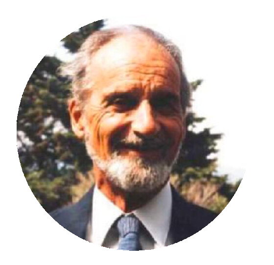
Joseph Andrew Tosi Olin was born on July 1, 1921, in Massachusetts, into a family that embodied America's immigrant tapestry. His father was an Italian-born civil engineer; his mother came from a Swedish culinary family. The boy who would spend his life measuring tropical rainfall and temperature gradients grew up in temperate New England, where the forests were deciduous and already mapped, where the ecology seemed settled and known.
He studied wildlife management at Massachusetts State College, then earned a master's degree in forestry from Yale in 1948. The timing was significant. Post-war America was investing in conservation, in scientific forestry, in the rational management of natural resources. But the focus was almost entirely temperate. The tropics remained a mystery, a green chaos that seemed to defy the neat categories and management principles being developed for northern forests.
Tosi's path toward the tropics began with his doctoral work. He enrolled at Clark University to study geography, choosing to focus his dissertation on forest land use in Puerto Rico. It was a prescient choice. Puerto Rico was where tropical ecology met American governance, where Spanish land-use traditions collided with U.S. forestry doctrine, where someone trained in temperate systems could begin to understand what made the tropics different.
It was during this Puerto Rico research that Tosi's life took its decisive turn. He met Dr. Leslie R. Holdridge, who had recently published a classification system that could predict what kind of forest should grow in any location based on climate data. Holdridge needed someone who could apply this theory to real tropical landscapes. Tosi, with his practical focus on land use, was exactly the kind of scientist Holdridge was looking for.
Holdridge invited Tosi to join the Inter-American Institute of Agricultural Sciences (IICA) in Turrialba, Costa Rica. Tosi accepted and arrived in 1951. The institute, nestled in the mountains east of San José, was one of Latin America's premier agricultural research centers. Tosi began working alongside Holdridge, learning how to apply the life zones system to real landscapes, not just theoretical diagrams. Costa Rica, with its extraordinary ecological diversity packed into a small territory, was the perfect classroom.
But Tosi's apprenticeship in Turrialba was brief. Within a year, the Organization of American States tapped him to direct their Forestry Program for the Andean Zone, based in Lima, Peru. He would spend eight years there, from 1952 to 1960, applying what he had learned from Holdridge across some of the most ecologically diverse terrain on Earth. The Andes presented ecosystems from coastal desert to high-altitude páramo, from dry valleys to cloud forests. For a land-use ecologist, it was advanced training. Tosi methodically classified the region's life zones, conducted field surveys, and advised governments on where forests could be sustainably harvested and where they should be protected.
In 1960, Tosi returned to Costa Rica. Holdridge was stepping down from his position as principal ecologist at IICA, and Tosi was the natural choice to succeed him. The student had become the master practitioner. He came back armed with eight years of experience applying the Holdridge system across an entire mountain range. Now he would have the chance to do the same for Costa Rica, working from the very institution where he had first learned the method.
The Law of "Improvements"
What Tosi encountered in his adopted country was a crude reality that jarred with the nation's verdant landscape. In the Costa Rica of the 1950s and 1960s, the boundless forest was seen as an obstacle, not an asset—undervalued and even despised as a resource. The primary antagonist wasn't a person or a corporation. It was a national policy: the ley de mejoras, or law of improvements.
This law was the engine of deforestation. It stipulated that any citizen could claim title to free lands by making "improvements" to them. The state's legal definition of improvement was simple: clearing the native forest. Transforming complex ecosystems into subsistence farms or, more often, into vast cattle pastures was rewarded with a deed.
Tosi watched this official, government-supported, and internationally-financed policy with the steady gaze of an ecologist. He saw it as a profound waste and destruction of an invaluable resource, all driven by a short-term and profoundly mistaken vision of development. He decided to fight against it.
But Tosi was not a political polemicist. He was an applied scientist. His battle would be waged not with placards but with data. His chosen weapons were technical reports and field studies. He would not simply argue that the forests were beautiful. He would provide the objective, scientific justification for a new national culture, one that would finally value the richness and importance of the country's natural resources.
The Life Zones System
Tosi had spent eight years in Peru applying Holdridge's classification system across diverse Andean ecosystems. Now, back at IICA in 1960, he would apply the same rigorous methodology to Costa Rica. The Holdridge Life Zones system was not new to him. But Costa Rica presented a different challenge: a small country with extraordinary ecological diversity, and a government policy that rewarded forest destruction.
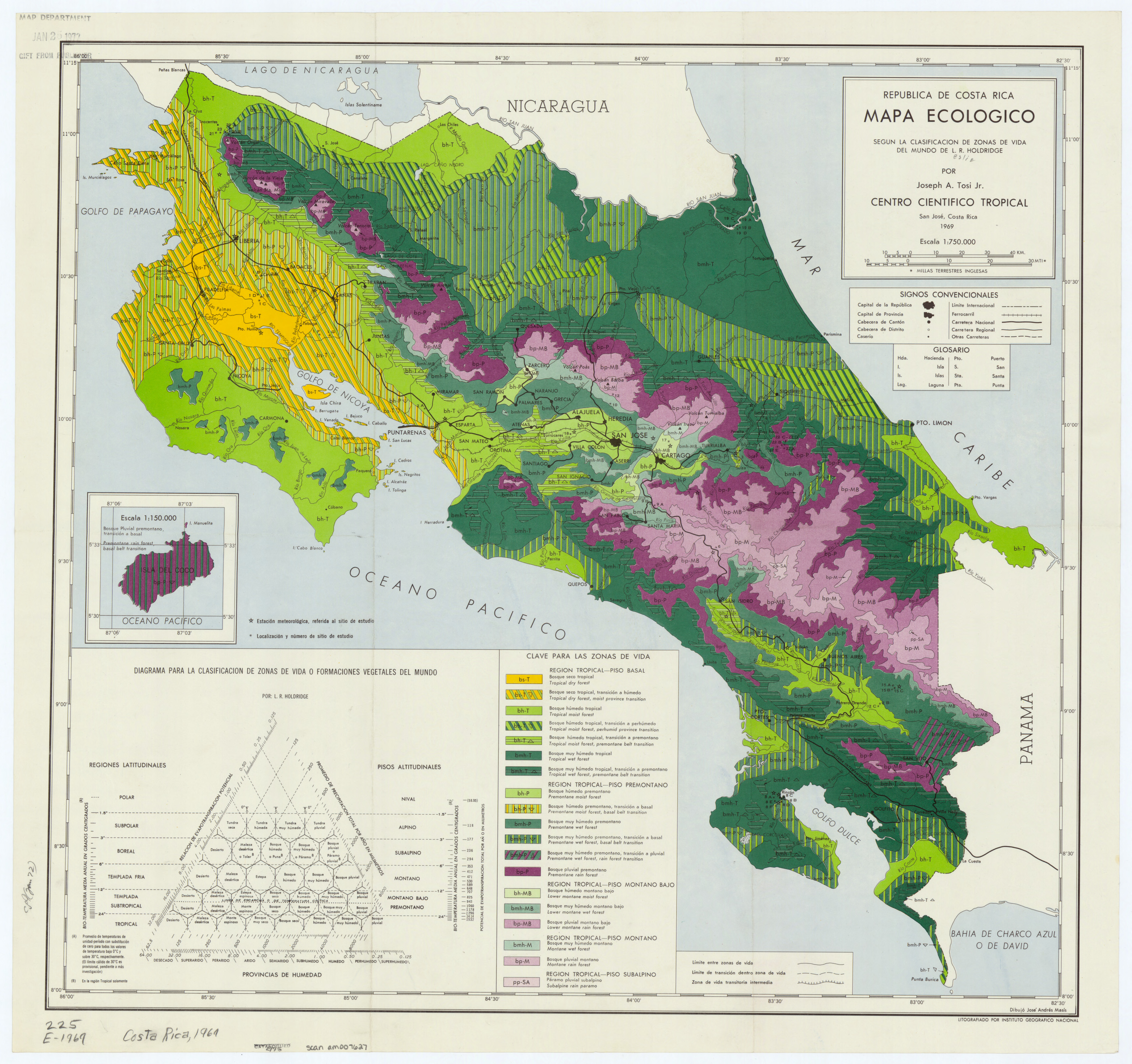
First published by Holdridge in 1947 and revised in 1967, the system was a global bioclimatic classification scheme. Its genius lay in what it chose to measure. It did not classify land by its current state, for instance, a depleted pasture. Instead, it classified land by its potential, defining the "climax vegetation" an area could support based on objective, empirical climatic data.
The system was an elegant three-axis model. It required only three key inputs: Annual Precipitation, Mean Annual Biotemperature (calculated as the mean of all annual temperatures after adjusting any temperature below freezing or above 30 °C to 0 °C), and Potential Evapotranspiration Ratio (PET), which relates the amount of water that could be evaporated and transpired to the amount of precipitation the area actually receives.
The system gave Tosi something the ley de mejoras could not refute: objective criteria for what land should be. Standing in a cleared cattle pasture, he could measure rainfall, temperature, and evapotranspiration, then state with scientific authority that this location, based on its climate, was a Tropical Wet Forest. The pasture was not an improvement. It was a misuse of the land's potential, a failure to take advantage of the high biological productivity the climate data showed this zone could support.
This was not an argument to convince individual ranchers. It was a tool for government. The system gave policymakers and park directors the scientific justification they needed to protect areas, to override economic pressure, to say no to development. Holdridge was the theorist, but Tosi was the applicator, the "Land-Use Ecologist" who brought the system from the abstract to the ground and put it in the hands of decision-makers.
Building the Infrastructure
Theory and data were not enough. Tosi needed an institution and a base of operations. In 1962, two years after returning to Costa Rica, he made his moves. First, he, Holdridge, Robert Hunter, and others co-founded the Tropical Science Center (TSC), a San José-based non-profit. Tosi served as its Administrative Director. The TSC was designed from the start as the institutional vehicle for applied conservation science, created to conduct research, consult with governments, and manage protected lands directly.
Second, that same year, Tosi made a subtle but brilliant tactical move. Alvin Wright, the manager of Osa Forest Products, a North American logging company operating on the Osa Peninsula, invited Tosi and Holdridge to visit. In a gesture of "collegial relations" with fellow foresters, Wright offered to lease the new Tropical Science Center two hectares of company land for a nominal yearly fee. His intent was to build goodwill. Tosi accepted. He built the Rincón de Osa field station just south of the company's airfield, planting a scientific outpost in the heart of what would become a decade-long battle.
The Osa Peninsula was a place of "structural magnificence and incredible biological variety," as Tosi himself would later write. But it was also under intense threat. The logging company held title to vast tracts of rainforest. A growing population of gold miners and land squatters, encouraged by the ley de mejoras, was pushing into the remote Corcovado basin. Tosi was positioning himself not just to study the peninsula, but to build the case for saving it.
For the next eleven years, from 1962 to 1973, the Rincón de Osa station was an "extremely active training center and research base." The TSC and the Organization for Tropical Studies ran field courses there. Well over 1,000 biologists, ecologists, foresters, geographers, and graduate students passed through, including a young Daniel Janzen. Each visitor "bore witness to the ecological diversity and complexity" of the Osa. Each left as what one observer called a "conservation partisan," an expert witness who had seen the peninsula's treasures firsthand. Tosi was not just collecting data. He was systematically building an influential, international constituency who would later prove decisive in the political battle to protect Corcovado.
While running the Osa field station, Tosi was also documenting the Holdridge system across the Americas. In 1967, he provided the crucial 100-photograph supplement for the revised edition of Holdridge's Life Zone Ecology. His photos were empirical evidence, the bridge connecting the system's abstract diagrams to the actual "natural vegetation and land utilization" he had meticulously documented across Central and South America.
Then, in 1969, Tosi completed his capstone project for Costa Rica: the República de Costa Rica, mapa ecológico. His methodology combined two approaches. Where weather station data existed, he used the Holdridge climate variables: biotemperature, precipitation, and evapotranspiration. But for most of Costa Rica, weather stations were sparse or nonexistent. For these areas, Tosi relied on what he called "direct field interpretation of vegetation." Twenty-five years of correlated field studies had taught him to identify life zones by observable plant characteristics, by the life-form and structure of undisturbed forest associations, even by secondary vegetation and certain cultivated crops that served as indicators.
The resulting map was more than cartography. It was a tool for national-scale land-use planning, a technical report in visual form. Government officials and park directors could look at any location and see what that land's climate and vegetation said it should be. The map became the blueprint for conservation decisions across the country.
Convincing the Quakers
While running the Osa field station, Tosi took on another project in 1968. The modern history of Monteverde ("Green Mountain"), a remote community perched high in the Tilarán mountains, began in 1951 when eleven Quaker families from Alabama purchased a large tract of land. They were pacifists avoiding the Korean War draft, choosing Costa Rica because it had abolished its army. They were farmers, not naturalists. They cleared the lower slopes for dairy farming and cheese-making but left the steep, primary forests on the mountaintop watershed largely untouched.
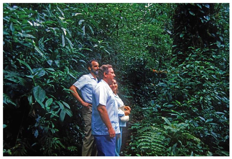
In 1968, Joseph Tosi and Leslie Holdridge made the journey up to Monteverde. The government's National Planning Office had commissioned them to conduct a survey. They met with Hubert Mendenhall, a leader of the Quaker community, who guided them into the primary forests.
The recommendation Tosi and Holdridge delivered was pragmatic, not emotional. It was not an aesthetic plea to "save the beautiful trees." It was a scientific assessment delivered to a community of farmers. They framed conservation in the language of practical self-interest.
Their survey concluded that the community should preserve the native forests for two critical, utilitarian reasons. First, the cloud forest was the source of their water, and protecting it was essential to protecting their water supply. Second, the forests on the ridgelines acted as vital windbreakers, shielding their fields, homes, and pastures from the powerful winds that swept through the mountains. This was a justification the farmers could understand and accept. It was not preservation for its own sake; it was conservation as a tool for their own community's survival.
That practical, science-based suggestion planted a seed. A few years later, a young graduate student named George Powell was conducting his doctoral research on the area's birds. He was, as others would be, "amazed by the outstanding biodiversity," including the endemic Golden Toad, a species found nowhere else on Earth. Powell was also alarmed by the growing encroachment of hunters and land squatters.
Determined to protect the area, Powell worked to secure land and used his own funds to buy out squatters. But he needed an institution that could legally hold and manage the property. He approached the Tropical Science Center. Among the organization's founding purposes was the ability to manage protected lands directly. In 1972, the Powells and the TSC formally established the Monteverde Cloud Forest Biological Preserve. Joseph Tosi and fellow TSC biologist Adelaida Chaverri personally sponsored the new reserve. The TSC took on the administration, and the protected area was soon augmented by the Quaker community's own watershed property, Bosqueterno S.A. Today, a trail in the preserve bears Tosi's name.
Corcovado: The Payoff
The Rincón de Osa field station had been operating for over a decade when the crisis came. By the early 1970s, the Osa Peninsula was at its breaking point. Osa Forest Products, under new and aggressive management, pushed forward with plans for massive resort development, including dredging a lagoon for an inland marina and building 2,000 home sites. In 1973, the new manager, Donald Allen, shut down Tosi's Rincón station permanently. Meanwhile, the Corcovado basin was exploding with squatters and gold miners.
Alvaro Ugalde, the director of Costa Rica's National Parks Service, had long wanted to protect the Osa. He had the will, but he needed a trigger and the science to back it. The trigger came in early 1975 when an Italian naturalist, frustrated by the inaction, wrote to President Daniel Oduber urging him to save the region. The president passed the letter to Ugalde and asked a simple question: what could be done?
Ugalde's first move was not to stage a protest or call a politician. His first move was to call his scientist. He asked Tosi to finish the Corcovado report that was being prepared on behalf of the World Wildlife Fund. This report was the culmination of Tosi's entire strategy. As project coordinator, Tosi synthesized a decade of research from the Rincón station. He and his team, which included Holdridge and the famed ornithologist Alexander Skutch, produced the technical assessment. This document, combined with Tosi's 1971 land-use potential map of the Osa Peninsula, gave Ugalde the scientific justification he needed.
While Tosi was finishing his report, tragedy struck. In late July 1975, Olof Wessberg, a Swedish conservationist who had created Costa Rica's first protected area at Cabo Blanco, was murdered on the Osa Peninsula. He had been conducting his own government survey, mapping boundaries for a Corcovado reserve. Hired assassins, funded by developers who saw the park as a threat to their interests, killed him and left his body in a shallow grave. His murder shocked the nation. What had been a scientific and bureaucratic process suddenly had a martyr.
The report's power was transformative. It was the first time in Costa Rican history that a national park was justified "only based on its ecological and scientific merits." Previous parks had been justified by recreational benefits, like Manuel Antonio, or cultural-historical significance, like Santa Rosa. Tosi's report, issued by the TSC, changed the very nature of the argument.
Tosi, the "highly regarded forester," presented his findings with the measured, objective voice of his profession. The full technical assessment - synthesizing a decade of research from the Rincón station, combined with his 1971 land-use potential map - gave President Oduber the scientific cover he needed. The report's most famous passage reveals how Tosi balanced rigor with wonder: "Long experienced in regions of lesser biological complexity and perhaps hardened to the esthetic experience of nature, trained biologists return from their first visit... with ecstatic praise..." Even here, Tosi treats his colleagues' inability to remain objective as observable, empirical evidence - awe presented as data.
But it was Wessberg's murder that provided the political will. On October 24, 1975, three months after the killing, Corcovado National Park was established. In his televised address, President Oduber invoked the Swedish conservationist who had "given his life to protect our forests." Tosi had provided the science. Wessberg had provided the sacrifice. Together, they made Corcovado untouchable.
The Surveyor's Legacy
Joseph Tosi is remembered today as a "visionary" and one of the essential "conservation pioneers" of Costa Rica. His legacy is foundational, yet often quieter than that of the political figures he worked with. While Alvaro Ugalde and Mario Boza are celebrated as the charismatic "fathers" of the national park system, Tosi was its scientific enabler. He was the one who provided the "pautas," the guidelines, in his "informes técnicos."
His legacy is also institutional. The Tropical Science Center, which he co-founded, embodied his philosophy. It was an organization designed "to conduct research... consult... and promote conservation through lobbying and direct land management." This model, using a non-profit scientific center to perform the rigorous fieldwork, provide the objective justification, and then manage the resulting private reserves like Monteverde, was a new and powerful engine for conservation.
The life's work of Joseph Tosi was a sustained, successful argument against the idea that progress requires destruction. His Mapa Ecológico and the applied Holdridge Life Zone system gave his chosen country a new, scientific language to understand its own natural wealth. He demonstrated, with methodical precision, that an ecological survey is far more than an academic paper. In the hands of a dedicated and strategic scientist, it is a non-negotiable justification for saving a nation's soul.
References & Further Reading
Foundational Works
Biographical essay on Tosi's life and work in Costa Rica, documenting his role as forest ecologist and conservation advocate.
The foundational text on the Holdridge Life Zones system, with Tosi's 100-photograph supplement documenting natural vegetation and land utilization across Central and South America.
Tosi's ecological map of Costa Rica based on the Holdridge system, a foundational tool for national-scale land-use planning and conservation.
Monteverde & the Tropical Science Center
History of Monteverde conservation, including Tosi and Holdridge's 1968 survey and recommendation to preserve forests for water and windbreak protection.
Overview of the reserve established in 1972 following Tosi's scientific recommendations, with the Tropical Science Center as managing organization.
Official history of the Tropical Science Center, co-founded by Tosi in 1962 as an institutional vehicle for applied conservation science.
Corcovado & the Osa Peninsula
Comprehensive documentation of Tosi's Rincón de Osa field station (1962-1973) and its role in training over 1,000 scientists who became conservation advocates.
Detailed account of how Ugalde called Tosi to finish the Corcovado report and how it became the first Costa Rican park justified solely on ecological and scientific merits.
Documentation of the Rincón de Osa station as an "extremely active training center and research base" from 1962-1973.
Academic study of Corcovado's creation, documenting Tosi's strategic approach and the scientific justification that enabled the park's establishment.
Overview describing the Osa as a "melting pot of diverse aspirations" and documenting the conflicts between development and conservation.
Holdridge Life Zones System
Overview of the classification system Tosi applied to demonstrate that cleared land was "Tropical Wet Forest" or "Premontane Rain Forest," not pasture.
Recognition of Tosi as the "Land-Use Ecologist" who brought the Holdridge system from abstract theory to practical application.
Institutional Context
Academic study describing the TSC as an organization designed "to conduct research... consult... and promote conservation through lobbying and direct land management."
Recognition of Tosi as one of Costa Rica's essential conservation pioneers alongside Ugalde, Boza, and others.