The Numbers Game
Costa Rica regulates forest development through percentage caps: 10% of forest area, 25% of agricultural parcels. These numbers sound precise. They can be measured, verified, enforced. But what if the percentages are measuring the wrong thing?
The appeal of percentage-based regulation is obvious. Numbers are objective. They can be measured, verified, enforced. Costa Rica's 1996 Forestry Law prohibits changing land use on forested land, but allows narrow exceptions for ecotourism infrastructure, national convenience, and related activities. The implementing regulation, Decreto 25721-MINAE, caps even those permitted activities at 10% of a property's forested area. The Subdivision and Urbanization Regulations allow 25% building coverage on agricultural parcels. These percentages feel precise. They create bright lines for permit decisions.
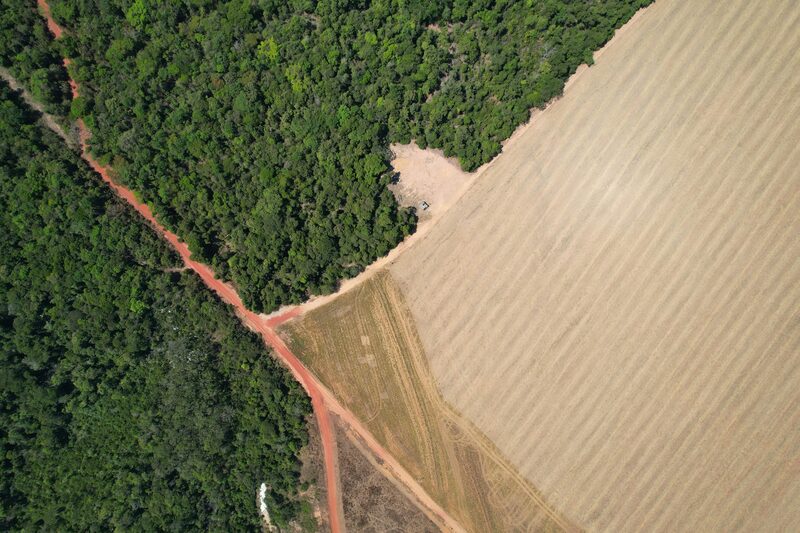
The problem is that forests do not experience development in percentages. They experience it in spatial patterns, in edge zones, in fragmentation, in the behavioral responses of the animals that depend on them. A regulation that measures only area misses most of what matters.
Where the 10% Came From
The 1996 Forestry Law (Ley 7575) requires that any forest cutting be "limitada, proporcional y razonable" - limited, proportional, and reasonable. It defines none of these terms. The law does not specify what forest intervention should be proportional to, what threshold qualifies as "limited," or what makes a clearing reasonable rather than arbitrary.
The implementing regulation, Decreto 25721-MINAE, did not merely fail to define these terms. It did not address them at all. The original 1996 Article 36 was four lines long, specifying only when environmental impact questionnaires were required. No percentage cap. No proportionality criterion. No reasonableness criterion. No mention of edge effects. No permit framework for forest intervention. The law demanded cutting be "limited, proportional, and reasonable." The regulation provided no mechanism to determine what those words meant. From 1996 to 2010, each of SINAC's eleven Áreas de Conservación decided for itself. Costa Rica's own REDD+ documentation acknowledges this: each Área was making rules "sin un sustento normativo que posibilitara unificar los criterios" - without regulatory support that would enable unified criteria.
Fourteen years after the law, Decreto 35883-MINAET (April 2010) finally amended the regulation to add explicit definitions. The "criterio de proporcionalidad" caps forest intervention at 10% of the property's forested area: "el área del bosque que autorice la Administración Forestal del Estado para la intervención y aprovechamiento de un porcentaje del área boscosa, el cual no podrá ser mayor del diez por ciento del área total (10%)." This is the origin of the 10% rule.
Nine months before the decree, the Procuraduría had warned the legislature against exactly this approach. In OJ-065-2009, reviewing a proposed amendment to Article 19, the PGR questioned whether percentage-based limits were wise: "para fincas de cientos de hectáreas, se estaría permitiendo el cambio de uso de suelo en decenas de hectáreas, lo que podría implicar la devastación de zonas enormes de bosques." For properties of hundreds of hectares, a percentage cap would permit land-use change across tens of hectares, potentially devastating enormous forest zones. The warning went unheeded.
The same decree added a "criterio de razonabilidad" that explicitly mentions what this article documents. The regulation now requires that intervention "cause el menor daño posible al área boscosa. Se priorizará la intervención en áreas menos sensibles, con mayor alteración y reduciendo el efecto de borde" - cause the least possible damage, prioritizing intervention in less sensitive areas with greater existing alteration and reducing edge effect. The regulation acknowledges edge effects by name.
The reform faced immediate challenge. Seventeen months after Decreto 35883 took effect, citizens led by Quirico Jiménez Madrigal filed an action of unconstitutionality (case 11-007738-0007-CO). Their complaint was direct: the decree "autoriza la tala de árboles hasta un 10%... sin contar con ningún tipo de sustento técnico" - authorizes tree-cutting up to 10% without any technical basis. They argued it created "el derecho... para devastar el 10% o más de los bosques privados" - a right to devastate 10% or more of private forests.
The Attorney General defended the decree, but the defense revealed its weakness. The Procuraduría conceded that the terminology "es confuso" - is confusing - because the decree's "plan de aprovechamiento" does not clearly equate to the stricter "plan de manejo" required by statute. More fundamentally, the PGR acknowledged that Article 19 of the Forestry Law "no contempla en forma expresa... el aprovechamiento forestal" - does not expressly authorize forest exploitation at all. To save the regulation, the Attorney General had to interpret its loose language as equivalent to requirements it never actually states.
The Constitutional Chamber dismissed the challenge. The seven magistrates ruled that the decree, "en sí misma, no resulta inconstitucional" - is not, in itself, unconstitutional. The plaintiffs, they wrote, "se limitan a presumir unos eventuales efectos" - merely presume eventual effects. The concerns were hypothetical. Yet in the same ruling, the Court acknowledged reality: "Claro está que esto no implica que, en la práctica, se puedan cometer abusos o situaciones ilegítimas" - of course this does not mean that, in practice, abuses or illegitimate situations cannot occur. The Court knew abuses were possible. It blessed the regulation anyway.
The Court's reasoning rested on a promise: permits would be granted through "resolución administrativa debidamente fundamentada" - properly reasoned administrative resolution - with case-by-case review ensuring environmental protection. If abuses occurred, ordinary courts remained open to challenge specific permits. The regulation was constitutional because the administrative system would catch the problems.
Fourteen years later, the Contraloría documented what that system actually delivers: 83% of SINAC forestry permits violated mandatory requirements. Ninety percent of SETENA environmental impact cases were approved without field inspection. Sixty percent of planned compliance inspections never happened. The "presumed eventual effects" became documented reality. The case-by-case review the Court relied on does not occur. The regulation acknowledges edge effects by name and does nothing measurable about them. The percentages came fourteen years late. The constitutional challenge failed. And the forests continue to fragment.
The 10% did not stay confined to forestry permits. Ten years after Decreto 35883 established the cap, Costa Rica's subdivision regulations incorporated the same threshold. Decreto 6411-2019, which governs how land can be divided, includes Article 34 addressing forested parcels: parcels with forest coverage can be subdivided, but remain subject to the Forestry Law's 10% intervention limit. The regulation even specifies that access easements count toward that 10%. Same percentage. Same problems. Different regulatory pathway. No coordination between them.
Edge Effects: The 10% That Destroys 90%
When you clear forest, you do not simply remove trees from the cleared area. You fundamentally alter the microclimate of the forest that remains. The newly exposed edge is subjected to conditions that interior forest never experiences: direct sunlight, wind, temperature fluctuations, reduced humidity. Trees at the edge die at elevated rates. Canopy gaps open. Pioneer species and vines invade the understory. The forest edge becomes something ecologically different from the forest interior.
Tom Lovejoy's forty-year experiment in the Brazilian Amazon documented precisely how far this damage penetrates. The Biological Dynamics of Forest Fragments Project (BDFFP), launched in 1979, deliberately isolated forest fragments of different sizes and monitored what happened. The results were unambiguous: edge effects penetrate at least 100 meters into remaining forest, sometimes 300 meters or more when wind turbulence is involved. Temperature at the edge rises significantly compared to the interior. Humidity drops. Leaf litter dries out. Fire risk increases. Tree mortality spikes within 100 meters of any edge.
The math is unforgiving. Consider a 10-hectare forest fragment, roughly 316 meters on each side, surrounded by pasture or development. Edge effects penetrate inward from all sides. Using the generous low end of Lovejoy's range, 100 meters, the unaffected interior shrinks to a square just 116 meters across: 1.3 hectares, or 13% of the original block. At the high end, 300 meters, the damage zones from opposite edges overlap completely. The fragment becomes all edge: hotter, drier, windier, with elevated tree mortality and collapsed understory. Interior-dependent species, the birds, insects, and mammals that require stable forest conditions, cannot persist. The fragment may still look like forest, but it can no longer function as one.
Now consider a larger block: 100 hectares, one kilometer on each side. At 100 meters of edge penetration, the interior shrinks to 800 meters across: 64 hectares, or 64% of the original. Substantial habitat remains. At 300 meters, the interior drops to 400 meters across: 16 hectares, just 16% of the block. Still enough for some interior-dependent species to persist, but the fragment has lost most of its ecological value. The relationship is not linear. Doubling the edge effect from 100 to 200 meters reduces the interior disproportionately, from 64 hectares to 36. The geometry punishes small fragments and rewards large ones.
But fragment size is only half the equation. Where you clear matters as much as how much you clear. Take that same 100-hectare block and split the difference on Lovejoy's range: assume 200 meters of edge effect. Clear 10 hectares in one corner, clustered together. The edge effect radiates into the adjacent forest, but the opposite side of the block remains untouched. Interior habitat survives. Now take the same 10 hectares and scatter it: nine one-hectare clearings distributed across the property, plus roads and infrastructure connecting them. Each clearing generates its own 200-meter edge effect. The overlapping degradation zones consume the entire block. Same total clearing. Radically different ecological outcome. At 300 meters, the scattered pattern would be even more devastating.
The Invisible Exclusion Zone
Edge effects are only part of the story. Large mammals do not simply avoid the cleared areas themselves. They avoid human presence, human activity, human infrastructure, often by distances far exceeding the physical footprint of development.
Research on large mammals shows behavioral avoidance zones that extend well beyond the physical footprint of human activity. Jaguars strongly avoid roads and human-modified areas, with some populations showing complete avoidance and others crossing roads only at elevated mortality risk. Female jaguars require home ranges varying from 25 to over 700 square kilometers depending on biome, prey availability, and habitat quality. A single road cutting through their territory can fragment what was continuous habitat into isolated patches. Baird's tapirs in Costa Rica show strong avoidance of roads and human settlements, with occupancy studies finding higher tapir presence at sites farther from villages and roads. White-lipped peccaries, which travel in large herds and require extensive forest for foraging, are among the first species to disappear from fragmented landscapes.
These animals do not measure the clearing. They measure the human activity. And human activity radiates far beyond the square meters the law counts.
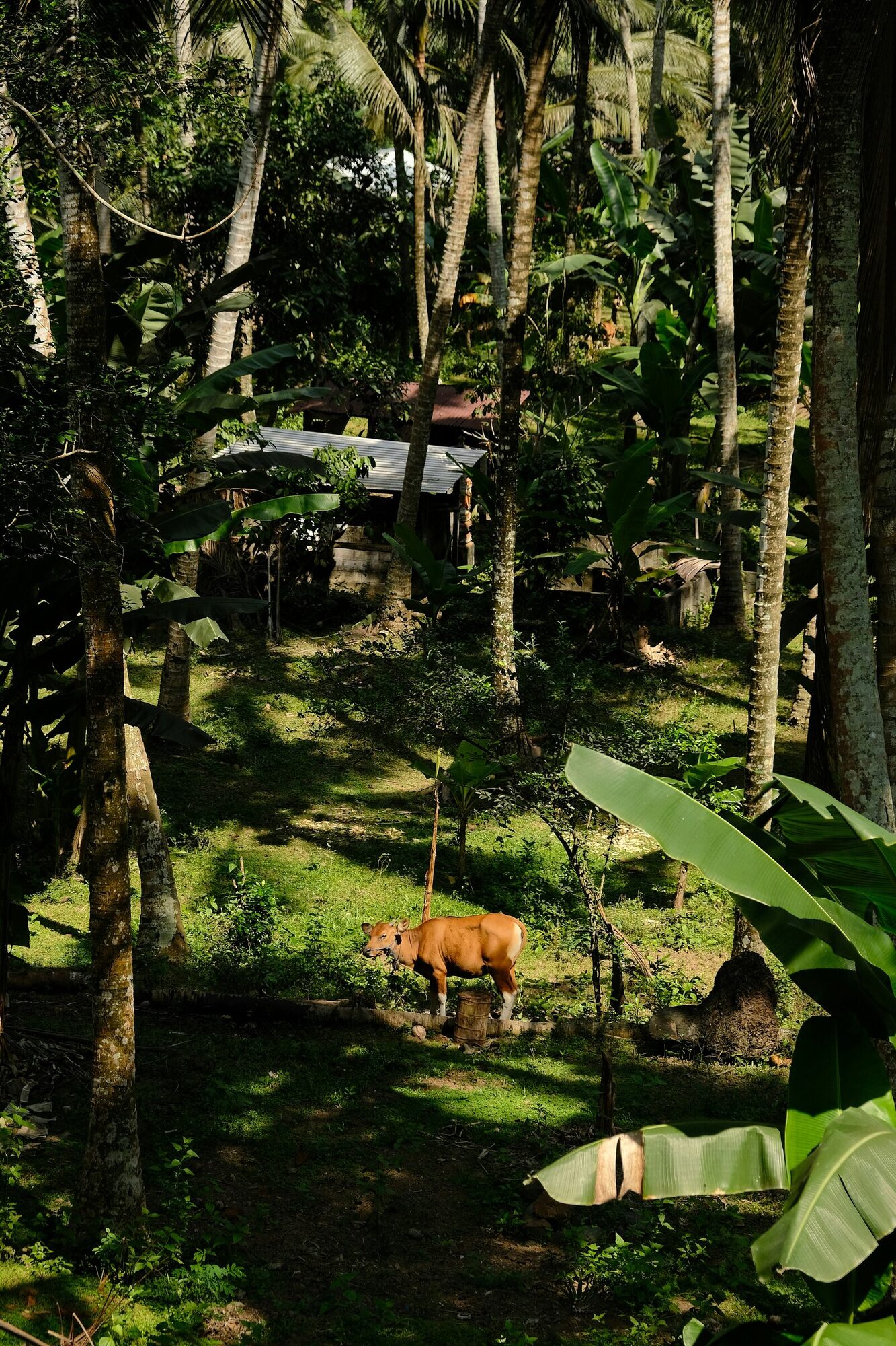
Return to our 10-hectare lot from the edge effects calculation. If the permitted hectare is one clearing in a corner, large mammals can still traverse the property and use the remaining forest. The clearing creates a dead zone, but the rest functions as habitat. The property connects to adjacent forest. Wildlife corridors remain intact.
Now scatter that hectare: the access road bisecting the property, the house at the center, the stable on the ridge, the office near the stream. Each structure radiates its own avoidance zone. The road alone, a permanent line of human activity cutting through the forest, may be enough to stop jaguars from crossing. What was one habitat becomes multiple fragments too small and too disturbed for species that need space and solitude. The lot is still 90% forested on paper. For a jaguar, it is 0% usable.
But edge effects and wildlife avoidance are not the only ways percentage limits fail. The regulatory system itself contains parallel pathways that compound the damage.

The 25% Waterproofing Cap
The percentage game extends beyond the Forestry Law. Costa Rica's Subdivision and Urbanization Regulations create a parallel system for agricultural, livestock, forestry, and mixed-use subdivisions. Agricultural parcels - land used for plantations, pasture, or other farming purposes that are not forested - can be subdivided with a minimum parcel size of 5,000 square meters (half a hectare) when accessed via agricultural easements rather than public roads. These "fraccionamientos agrícolas" allow up to 25% of the parcel area to be "waterproofed" - covered with impervious surfaces like buildings, concrete, or asphalt that prevent rainwater from soaking into the ground. The breakdown: 10% for a single-family house (maximum 300 square meters), workers' housing, and "agritourism infrastructure," plus 15% for agricultural buildings like warehouses, stables, and greenhouses.
The definition of "agritourism infrastructure" is narrow. The Attorney General's Office (Procuraduría General de la República) defined it in Opinion PGR-C-339-2004: agritourism involves visitors in the agricultural activities that are already taking place on the property. It means inviting tourists to participate in coffee harvesting, cattle work, or farm operations. It does not mean building tourist accommodations that happen to be located on agricultural land.
The misuse pattern is straightforward. A developer acquires agricultural land and subdivides it legally, creating parcels of 5,000 square meters accessed by agricultural easements rather than public roads. This avoids the requirements of urban development: no public road frontage needed, no urban services required. On paper, the land is for farming. But then the developer obtains permits that exceed what the regulations allow: cabins, restaurants, and tourism infrastructure that go beyond the narrow definition of "agritourism infrastructure" meant for working farms. These are properties accessed by easements, not properties facing public roads - a legally critical distinction. Properties with public road frontage can be developed for tourism with up to 75% coverage under different regulations. Properties accessed by agricultural easements cannot. Yet municipalities grant the tourism permits anyway, either not understanding the distinction or choosing not to enforce it.
The result is tourism development on land that was never zoned for it, using infrastructure caps designed for working farms. Municipalities enforce the 25% waterproofing limit, but they do not track whether the infrastructure serves the agricultural purposes that justified the subdivision in the first place. Cabins and restaurants replace crops and pasture on land subdivided as agricultural.
Socolado: Gaming the Definition
The percentage limits only matter if the land qualifies as forest. Costa Rica's Forestry Law defines forest with specific thresholds: an ecosystem of 2 or more hectares, with canopy covering more than 70% of the surface, and more than 60 trees per hectare with diameter at breast height of 15 centimeters or greater. Degrade a forest below any of these thresholds and it no longer looks like forest under the statutory definition. That gap between legal reality and physical appearance is the opening developers exploit.
There is a practice common among developers seeking to escape these protections: degradation by attrition. The technique has a name: socola or socolado. Trees conveniently fall during rainstorms. The fallen trees are "cleaned up" and removed. Cleared areas are kept cleared. Forest understory is chopped extensively, preventing regrowth. Grass seeds are sown. Over several years, the original forest structure gradually changes to tree-shaded pastureland.
When SINAC inspectors arrive, they find a degraded lot that appears to fall outside forest protections. The canopy cover is below 70%. The understory is grass rather than forest vegetation. The developer shrugs. The inspector shrugs. The permit issues.
Costa Rican law does not permit this. The Procuraduría General, confirming a doctrine elaborated by the Tribunal de Casación Penal, has recognized a principio de irreductibilidad del bosque: the space occupied by forests is irreducible. A forest degraded below the statutory thresholds does not stop being forest. In C-200-2009, the Procuraduría stated that accepting that Article 19's protections disappear through subsequent human actions aimed at eliminating the forest's original conditions "would be to encourage a devastating attitude toward these ecosystems to circumvent the Law."
Socolado is, accordingly, a crime. The Fiscalía Agrario Ambiental's Circular #11 states explicitly that "even cutting the lower stratum of forest (understory) and introducing improved pastures constitutes a change of use, because such anthropic work prevents the natural regeneration of the ecosystem." The offense is classified as a delito de efectos permanentes, a crime of permanent effects. Under Article 32 of the Código Procesal Penal, there is no statute of limitations as long as the effects persist by the will of the accused.
The practice is so well-known that the implementing regulation names it explicitly. Decreto 25721-MINAE, Article 2, defines "Combinación de Especies Forestales" (agroforestry combinations) but specifically excludes "bosques socolados, o fuertemente intervenidos donde se abre un espacio que permite el establecimiento de especies forrajeras o agronómicas." Socolado forests cannot escape forest protections by claiming to be agroforestry systems.
The scale of this circumvention is documented. A 2005 study by SINAC and FUNDECOR, cited by the Procuraduría in C-200-2009, found that "extensas áreas que en 1996... eran bosque, han sido convertidas en potreros o sistemas agroforestales para burlar su protección," extensive areas that were forest in 1996 have been converted to pastures or agroforestry systems to circumvent their protection. In the Central Volcanic Range Conservation Area alone, 30% of the trees cut with legal permits between 1999 and 2001 were part of a forest in 1996. Another 11% were within 25 meters of the current forest edge, indicating pressure to change use at the boundaries.
The incentives to attempt this are substantial. A developer whose land is classified as forest faces Article 19's prohibition on land use change. Socolado offers a way around it: degrade the forest until it no longer resembles one, then present the land to SINAC as something that was never forest to begin with. Records must have been in error. Permits, please. One specific benefit is access to Article 27 of the Forestry Law, which allows tree cutting on "terrenos de uso agropecuario y sin bosque" under far easier requirements than native forest management: a simple inventory approved by regional councils in days, rather than detailed management plans prepared by licensed forestry professionals, environmental impact assessments, and months of bureaucratic process.
Costa Rica's own submissions to the UNFCCC acknowledge the problem. In REDD+ documentation, the government describes how "by cutting the understory and sowing grass seeds, the original forest structure gradually changes to tree-shaded pastureland, making it more convenient for landowners to achieve legality for harvesting trees since it does not require a bureaucratic process like native forest management." The state recognizes that socolado is used precisely to circumvent forest protections.
As a countermeasure, Costa Rica implemented GPS georeferencing and designated the 2000 Forest Cover Map as the official baseline for land classification disputes. A forest that appeared on the 2000 map but has since been socolado into pasture still technically enjoys legal protection. The baseline proves what existed; the current aerial shows what remains. The gap between them is the evidence. SINAC's understaffed regional offices may lack resources for complex investigations, but the legal framework does not require proving who caused the initial damage - only who is maintaining the degraded state. The 2-hectare threshold adds another wrinkle: the law defines forest as ecosystems of 2 or more hectares, but this refers to the continuous ecosystem, not property boundaries. A developer who fragments a large forest into smaller degraded patches may still be liable for the aggregate destruction.
But the 2000 baseline establishes a minimum, not a ceiling. Article 19's prohibition on land use change applies to "terrenos cubiertos de bosque" - land covered by forest. If abandoned pasture regenerates to meet the legal definition of forest - more than two hectares, more than 60 trees per hectare of at least 15 centimeters diameter, more than 70% canopy cover - it becomes protected under Article 19, regardless of what the 2000 map showed. The Procuraduría General has confirmed that accepting any other interpretation "would be to encourage a devastating attitude toward these ecosystems to circumvent the Law." The 2000 map provides ironclad proof of historical forest cover for enforcement purposes. But newly formed forests enjoy the same protection as their ancient counterparts once they meet the statutory definition.
The "It Wasn't Me" Defense
Landowners confronted with socolado on their property have a predictable response: denial. The tree fell in a storm. Intruders cut the understory at night. Animals kept the clearing from regenerating. I had nothing to do with it.
Costa Rican environmental law provides a comprehensive answer to this defense, built on three interlocking doctrines.
First: liability by omission. Article 101 of the Ley Orgánica del Ambiente establishes that property owners are jointly and severally liable for environmental damage "ya sea por acción o por omisión" - whether by action or omission. The initial clearing may have been caused by a storm or by trespassers. But the owner who maintains the cleared state - by mowing, by grazing cattle, by removing regrowth - is committing an ongoing act of environmental damage. The cause of the initial damage becomes irrelevant. What matters is who is perpetuating the effects.
Second: the guarantor position. Costa Rican criminal doctrine recognizes the posición de garante - a duty of supervision, vigilance, and control that attaches to certain roles. Property owners occupy a guarantor position with respect to environmental conditions on their land. The Fiscalía Adjunta Ambiental has stated that "citizens have a guarantor position for the environmental good, although some people have greater responsibility." A landowner who fails to prevent degradation, or who fails to allow natural recovery, may be liable not just for what they did, but for what they failed to prevent.
Third: responsabilidad propter rem. Environmental liability in Costa Rica is "ambulatory and inherent to the property." The pasivo ambiental - the environmental liability - travels with the land from owner to owner. You cannot escape responsibility by claiming you bought the property already degraded. The obligation to restore transfers with the deed. This doctrine, combined with the constitutional función ambiental de la propiedad established in Article 8 of the Ley de Biodiversidad, means that property ownership is not merely a bundle of rights but a bundle of duties. The owner's exercise of property rights is conditioned on fulfilling environmental obligations.
The implications are concrete. A tree falls in a storm: nature caused this, the owner bears no fault. The owner clears the fallen trunk and maintains the gap: now the owner is actively preventing regeneration. The owner grazes cattle in the clearing: each day the cattle eat emerging seedlings is a new act of environmental damage. The owner sells the property: the new owner inherits the liability and the duty to restore.
The phrase from Circular #11 bears repeating: the offense is a delito de efectos permanentes with no statute of limitations "as long as the effects persist by the will of the accused." The key word is will. If degradation persists because the owner chooses not to allow regeneration, the effects persist by the owner's will. The clock never starts running. The defense of "it wasn't me" only addresses who caused the initial damage. It does not address who is maintaining the ongoing harm.
Beyond Percentages
Each of these percentage limits was designed in isolation. The Forestry Law does not coordinate with the Subdivision Regulations. Neither coordinates with municipal permitting. No agency sees the cumulative effect of a developer who exploits multiple systems simultaneously.
The cumulative impact problem is straightforward. A developer acquires a large forested property and subdivides it legally under Article 34 of Decreto 6411-2019, creating multiple parcels accessed by easements. Access roads fragment the canopy. Some parcels are degraded through socolado - understory clearing followed by pasture - until they no longer meet the forest definition and can receive construction permits from the municipality as non-forested land. On remaining forested parcels, the developer applies to SINAC for Article 19 permits: an ecotourism lodge on one parcel, agricultural offices on another, equipment storage on a third. Each application arrives separately, shows compliance with the 10% cap for that parcel, and is approved. No reviewer sees that these are part of a coordinated development across what was once continuous forest.
The result is a fragmented landscape: scattered clearings separated by roads, pasture, and buildings. What was one functioning ecosystem becomes isolated patches. The remaining tree cover cannot support wide-ranging mammals. Birds that require interior forest avoid the disturbed areas. Edge effects penetrate throughout because even 10-hectare patches surrounded by clearings experience edge conditions across their entire area. Functional habitat becomes, through entirely legal means, a patchwork that provides neither forest nor meaningful ecological service. This pattern appears in regions across Costa Rica where development pressure meets percentage-based regulation. No single permit exceeds its cap. Each agency approves its piece without seeing the cumulative pattern.
The regulatory blindness is structural. Each agency operates within its statutory mandate. SINAC enforces the Forestry Law: its jurisdiction is the 10% cap per property, the requirement that intervention be "limited, proportional, and reasonable" as defined by Decreto 35883-MINAET. Municipalities enforce the Subdivision Regulations and building codes: their jurisdiction is the 25% coverage rule, setback requirements, infrastructure standards. SETENA reviews environmental impact statements: its jurisdiction is the D1 and D2 questionnaires, 90% of which are approved without field inspection. No statute assigns responsibility for cumulative impact assessment across adjacent parcels. No regulation requires inter-agency coordination. No legal framework exists to say: ten adjacent properties are being developed simultaneously; someone must evaluate the landscape-scale effects.
The Constitutional Chamber's 2011 ruling blessing Decreto 35883 rested on a promise: that permits would be granted through "resolución administrativa debidamente fundamentada" - properly reasoned administrative resolution - with case-by-case review ensuring environmental protection. If the regulation itself was not unconstitutional, the Court wrote, any abuses in practice could be challenged through ordinary litigation. But case-by-case review, by definition, cannot detect cumulative patterns. When ten applications arrive on ten different days to ten different reviewers, no individual reviewer sees the whole. The system was designed to evaluate parcels. It cannot evaluate landscapes.
The problem is not the numbers themselves. Percentage caps are not inherently flawed. The problem is that they measure the wrong thing. They measure area cleared, not ecological impact. They measure physical footprint, not functional habitat. They measure compliance on individual parcels, not cumulative effects across landscapes.
Effective forest regulation would need to account for spatial distribution: not just how much is cleared, but where and in what pattern. It would need to consider edge effects: recognizing that a linear road creates far more damage per hectare than a compact clearing. It would need to assess connectivity: whether the remaining forest still functions as habitat, still connects to adjacent protected areas, still allows wildlife movement. Most importantly, it would need to see the whole board. When ten landowners each clear 10% of their adjacent properties, the cumulative impact is not ten isolated clearings. It is a fragmented landscape where edge effects overlap, wildlife corridors are severed, and what was one functioning ecosystem becomes many degraded fragments.
Return to the question posed at the beginning: what if the percentages are measuring the wrong thing? They are. They measure area. Forests measure connections. A regulation that counts hectares cleared cannot see the web of relationships that makes a forest function: the understory that moderates temperature and humidity for canopy trees, the continuous canopy that allows monkeys to travel without descending to predator-rich ground, the interior zones free from edge effects where sensitive bird species can nest. Ten percent sounds precise. It measures nothing that matters.
The 1996 Forestry Law demanded that forest intervention be "limitada, proporcional y razonable" - limited, proportional, and reasonable. For fourteen years, the law stood without implementation. In 2010, Decreto 35883-MINAET finally defined those terms. Proportionality became a percentage: 10%. Reasonableness became a checklist: prioritize less sensitive areas, minimize damage, and - the decree said it explicitly - "reduciendo el efecto de borde," reducing edge effect. The regulation acknowledged by name the phenomenon this article documents. But acknowledgment without measurement is not protection. The decree says reduce edge effects; it provides no metric for what "reduced" means, no threshold for unacceptable fragmentation, no mechanism to evaluate whether a particular intervention pattern violates the principle even while respecting the percentage.
The science is clear. The legal framework has the bones: Article 19's demand for proportionality, the Constitutional Chamber's standard of reasonableness, SINAC's technical authority to define forest management criteria, the explicit regulatory instruction to reduce edge effects. What remains is to write regulations that measure what the forests actually experience: not percentages, but patterns; not area, but connections; not individual compliance, but cumulative impact.
Key Sources & Resources
Edge Effects & Forest Fragmentation
Comprehensive analysis of edge effects from the BDFFP project, documenting how damage penetrates 100-300+ meters into remaining forest.
Long-term findings from the world's largest and longest-running experiment on forest fragmentation.
Quantifying how quickly species disappear from forest fragments of different sizes, with implications for minimum viable habitat areas.
Wildlife Behavior & Avoidance
Research on jaguar space requirements and avoidance of human-modified areas, including data on home range sizes and road avoidance.
Comprehensive telemetry study of jaguar home ranges across Brazilian and Argentine biomes, documenting female ranges from 25 to over 700 km² depending on habitat.
Occupancy study in Costa Rica's San Juan-La Selva Biological Corridor finding that tapir occurrence was positively associated with distance from villages, indicating avoidance of human settlements.
Study of wildlife underpasses on Route 34 in Costa Rica demonstrating considerable reduction in mammal mortality including Baird's tapir when crossing structures are present.
Regulatory Documents
Prosecutorial circular establishing that understory cutting constitutes change of use, with no statute of limitations while effects persist.
Costa Rica's official REDD+ submission acknowledging the socolado practice and describing countermeasures including GPS georeferencing and the 2000 Forest Cover Map baseline.
The original 1996 implementing regulation. Article 36 was just four lines about EIA questionnaires. No 10% cap, no proportionality criterion, no reasonableness criterion, no mention of edge effects. The entire permit framework was created from nothing by Decreto 35883 in 2010.
The current consolidated text with all amendments through 2010. Compare with original above to see what Decreto 35883 added: the 10% cap, proportionality and reasonableness criteria, edge effects language, and the entire permit framework.
The 2010 decree that finally defined the terms the law left undefined for fourteen years. Added "criterio de proporcionalidad" capping intervention at 10% and "criterio de razonabilidad" requiring that intervention "cause el menor daño posible... reduciendo el efecto de borde."
The Constitutional Chamber's dismissal of citizens' challenge to the 2010 reform. Plaintiffs argued the decree created "el derecho para devastar el 10% o más de los bosques privados." The Court acknowledged abuses could occur "en la práctica" but found the regulation constitutional, trusting case-by-case administrative review.
The Attorney General's defense of the 2010 reform against citizens who argued it authorized forest clearing "sin que existan estudios técnicos." The PGR conceded the decree's terminology was "confuso" and that Article 19 "no contempla en forma expresa... el aprovechamiento forestal."
Official guidance clarifying that cabins and restaurants are not permitted on agricultural parcels, and that illegally issued permits are the municipality's responsibility.
August 2025 Contraloría audit finding that 83% of SINAC forestry permits violated mandatory requirements, with SIREFOR information system described as "obsolete, inefficient and dependent on third parties."
News coverage of Contraloría audit findings that 90% of SETENA environmental impact cases were approved without field inspection and 60% of planned compliance inspections were never executed.
Current subdivision regulation (effective September 2020). Article 34 establishes special rules for forested parcels: 20,000 m² minimum parcel size, subject to Forestry Law's 10% intervention limit, with easement areas counting toward that limit. Replaced Decreto 3391-1982.
Environmental Liability Law
Establishes that property owners are jointly and severally liable for environmental damage "whether by action or omission," including liability extending to titleholders of properties where damage occurs.
Constitutional basis for the función ambiental de la propiedad, establishing that property ownership is conditioned on fulfilling environmental obligations.
Legal analysis of environmental liability doctrines including responsabilidad propter rem (liability that travels with the property) and the prohibition of eco-abuse of rights.
Judicial analysis of environmental damage, statutes of limitation, and the concept of delito de efectos permanentes in Costa Rican law.
Prosecutorial policies establishing that citizens have a "guarantor position" (posición de garante) for environmental goods, with property owners bearing heightened responsibility.